Tuesday, May 13, 2014

May 12 - Our incredible drive to Indemini, Switzerland - Woohoo!

We rented a car for the week since the weather was good. Our time here is coming to a close and yet there were so many places we wanted to explore!  Although we could also take a bus to Indemini, it was much faster to drive. 

Now, why Indemini? I discovered this town way deep and high up in a valley near Locarno, near the Italian border, while looking at Google earth. It sits at 3,117 feet above sea level in the Valle Veddasca. The settlement began in the 1200's and was isolated until 1917-18 until a road was built on the Swiss side.  Indemini is near a river which forms the border between Switzerland and Italy.  There are a number of towns on the Italian side of the river all the way down to Lake Maggiore, and in fact, in the 1800's Switzerland tried to swap Indemini with the Italian town of Campione d'Italia (which is actually located within the Swiss borders), but Italy said no.  

So Rick and I made the climb by car from the Swiss end of Lake Maggiore, above Magadino, across from Locarno.  And oh boy! What a climb! I actually had thoughts of turning back. (Very unlike me!) 

My theory is always that "if the postal bus goes here, I can go here!" And yes, the postal bus drives this route about 6 times a day, year round! Yikes! (It's more of a big van). There were a couple of bus stops in the middle of nowhere - but near a hiking path, of course. One good thing was that we encountered only one car. It would have been more frightening with traffic - one advantage to the off season. 
As we climb up the mountain towards Indemini, looking back across Lake Maggiore to the Valle Verzasca near Locarno. You can see the big dam at the entrance to the valley. 
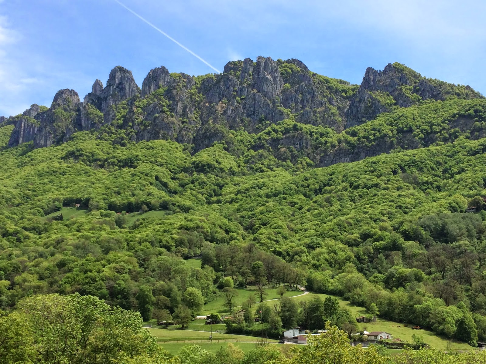
We zig-zagged up steep switchbacks over and over, for about 30 minutes straight - no towns, nothing, until we suddenly popped out into the open at the top of the pass called the Alpe di Neggia. Cold up there! 
Lots of paths to hike up there! There is a restaurant there but it was still closed.  I'm sure it's hopping in summer! 
Looking again at the dam and its lake across in the Valle Verzasca. I think you can get an idea of how straight up we are and how steep that mountain drive was! 
The view looking over the other side of the pass towards Italy and another part of Lake Maggiore (it's a long lake!) The first town you see on the right slope is the first town in Italy, Biegno. Indemini is closer to where I took this picture but not visible. 
A small group of homes, a "suburb" of Indemini near the pass called Monti Idacca. 
Zooming in on a meadow across the valley. There are some old stone houses but the grocery store lady said no one lives there any more. (There are no roads!)

Indemini, Switzerland
. We parked the car in Indemini and then spent our day exploring this very old town.  It is one of the best examples of a large town that basically has not changed much in hundreds of years. There are only about 60 people that live there year round, but the number swells to about 300 in summer with many summer homes. 
We walked into a museum which has some interesting papers from the 1700's. One spoke of a sudden illness killing 30 residents, and on top of that the winter was harsh and food was scarce. So hard to imagine how they did it! 
Indemini, Switzerland
For any future visitors of Indemini - you can all and arrange of tour of the town! Wish I knew about this before we made the trip. 
Indemini, Switzerland
Great summer home! 
Rick and I had packed a lunch and found a nice spot in the grass by the church. Earlier, we spoke to a woman in the tiny grocery store.  Speaking with her, we realized we were in the valley on the other side of Monte Lema and Monte Tamaro. We can see both from our house. We bought from her some Peppe Aromatizato di Valle Maggia. We had just learned about this pepper. It's made in Valley Maggia near Locarno and cooked with wine and other spices. Very unusual and really good! (It can also be found in Lugano). 
I asked the woman about the road through Italy, if it was as steep. She said it was about the same but maybe a gentler ride. We decided that would be our way home. I was getting nervous at the thought of going back down on the Swiss side! 

Our picnic spot near the church. See Rick sitting in the grass?
A green and turquoise lizard I spotted! (usually they are just brown) 
Indemini, Switzerland
 Indemini, Switzerland
Indemini, Switzerland


Indemini, Switzerland
On our ride back down on the Italian side, we see the town of Monteviasco, Italy. There are no signs of roads, only of a pulley system to bring things up there. This Italian town is furthest into the valley on that side of the valley. 

Don't drive too fast - you never know what you'll encounter on the road! 

Another view of Monteviasco on the other side of the valley. 
So it was quite a nice ride done the Italian side and I was surprised to see quite large Italian towns so high up in that valley also! It's really amazing and worth a trip here to experience it. 
When all was said and done, we were SO happy we made this trip to Indemini. It was worth the white knuckles! 

We have arrived down the mountain to Lake Maggiore, over the town of Maccagno, Italy

May 9 - Hike from Villa Luganese to the Grotto Monte Creda

We took a shorter hike this afternoon. We had made plans to go to dinner that night with the head football coach and his family to this grotto up in the mountains. Since we had never seen it, we thought we'd take a hike to check it out! 
Now, let me explain.... There are many grottos in Ticino, which are usually mountain restaurants that have been there for a long time and serve a limited menu of mostly homemade food. Often the cheeses and meat are from the nearby mountain farms. 
So we began our hike from the town of Villa Luganese and followed the signs up to the grotto. You can take the steeper climb on the mountain path or take the paved road. We did a little of both and it was a 1/2 hour hike. 
The picture above is from the meadow next to the grotto. 

That is Monte Tamaro in the background with the snow. 

The grotto is the building below. 
Along the hike down were directions to many hiking paths! The "Denti della Vecchia" mountains in the background. 
Eating outside at the Grotto Monte Creda. 


The head coach of the Lakers at the grotto.

Sunset at the grotto.

Thursday, May 8, 2014

May 8 - Hike from Villa Luganese to Rosone, under the "Denti della Vecchia"


 The Denti Della Vecchia (the old lady's teeth as they call those mountains.)

It was easy to begin this hike since we just took the 461 ARL bus from Pregassona to Villa Luganese, which is just up the road and back towards the end of the valley. When we got off the bus, we really didn't know which way we would go. I saw a group of homes up on the mountainside so we decided to go there! It was an area called Rosone. 
 This time, the sentiero signs were along the road, so we just kept hiking upwards and it was quite easy since we were on a road. I really enjoy using my Gallileo offline maps on my iPhone, since I can check where I am by satellite at any time. It works quickly and without internet or any data use! 
 Up and up we go. The Denti on the left, and in the distance a couple of shimmering spots of Lake Lugano. There are many meadows up here and also mountain homes. 
The highest point we went to was basically at the end of the road - a place called Petrolzo. I believe there was a farm up there that made and sold cheese. I know that you can just go to these mountain farms and buy cheese directly from them. Unfortunately they were no open at the time we were there. 

 At the point of the cheese farm, there was a sentiero (path) sign heading down a dirt road which said 1 hour to Sonvico. It also pointed back the way we came and said 1 hour to Sonvico. Sonvico is basically next to Villa Luganese. I preferred to hike the new route back. We followed the road which came to an end - well, it continued (and there were cars parked there) but there was a barrier and it said private. But I saw the sentiero sign pointing downwards through the forest, so we went! This path at this point was not as well defined, on the ground, but there were many markings on the trees, so we had no problem. 
Rick was a bit hesitant, but come on! We've done this before! 
Then we came out in the pasture in the picture above. We found a nice rock which naturally formed a chair and ate our snacks. 
 At the edge of that meadow the path continued down towards a stream. How long have these signs been on this tree? Quite funny! 
 Rick, after crossing the river. Half of the little bridge was out, but rocks placed in just the right place helped. And so did my hiking sticks! 
 In this picture we can see Monte Tamaro in the distance, with snow. As we had walked through the woods, we could see a number of old, abandoned stone houses. It's amazing to think there were people living all over in the mountains so many years ago. A very difficult life! 
 Little farms dot the landscape
 The Denti della Vecchia are really impressive when you see them towering right in front of you! 
Typical orange sentiero signs. Usually just orange signs mean it's an easy walk. Signs with red and white means there is some up and down, rocks or tree roots for steps. I've never had a problem with the red and white sign trails. If you ever see a hiking sign with blue, you better be a skilled mountain climber! 
 The spring flowers in the meadows are abundant and beautiful! 

 A little farm under the Denti della Vecchia

 We made our way back to Villa Luganese - we had hiked for a total of 4 hours! TIRED! I took this picture from the cemetery in town, because you can see where we had hiked - the area called Rosone. 
Look in the center of the picture on the green mountain on the left half of the picture. There are a few white dots in the green trees. That's Rosone, and the cheese farm was up towards that open area a little up and right of Rosone. 
It was a far walk! 
The outside of the church in Villa Luganese has arched porticos which have frescos on them. It's so amazing to see the date - 1577!
It was 5:15pm when we had arrived back in Villa Luganese. We walked around until 5:30 when the Grotto degli Amici opened. It is an adorable grotto with outside seating under huge trees.  Rick enjoyed some ice cream and I had a panaché. I don't know if they served panaché in the US - it's 1/2 beer and 1/2 sprite or 7-up or lemonade. It's really good and refreshing! It's also worth going inside the grotto restaurant, as it is SO charming inside! We plan to go back to eat dinner there some evening. 
The ARL 461 bus leaves from right across the street from the Grotto every half hour, so this is a convenient place to go from our home in Pregassona. 
A super day! 

Wednesday, May 7, 2014

May 5-6 Trip to Zurich - Üetliberg, Rapperswil, & boat ride on Lake Zurich, funny photos

 On May 4 Rick coached the Lugano Lakers senior team in Biel/Bienne, Switzerland. The town has 2 names, because it is truly a bilingual city - French and German. I rode with the team on the bus and we arrived in Biel/Bienne at noon. There was some time before the game began, so I took off to explore the city for a bit. Since I didn't really know what to expect or where to go in the city, I didn't see the best parts (so no pictures there). But on the way back to the field, I went the wrong way on the bus, so instead of a 10 minute ride back, I took the LONG way and it took 50 minutes! Now, this wasn't so bad after all, since it gave me an overview of the city and it was quite nice! I plan to visit again another year!  

Unfortunately the Lakers lost - by quite a bit - don't even know the score. (there were no score boards so it's hard to know!)

After the game Rick and I took a bus to the Biel/Bienne station and then the train to Zurich. For anyone with a smartphone, I highly recommend the Swiss train/bus system app - SBB. I punched in where we wanted to go and purchased our tickets right from the app - for our bus and train! It's wonderful! 

On Monday we met our dear Swiss friends, Urs and Brigitte. They just moved back to Switzerland after living in Chicago for 2 years. They had just visited us in Lugano, and now it was our turn to see where they lived - in Wetzikon, near Zurich. 

 The first place we went together was the Üetliberg - a lookout point on a mountaintop a bit southwest of Zurich. 
The Alps were fairly clear in the distance, but unfortunately they look much further in my photos. They were really impressive and felt much, much closer in real life! 
 I'm zooming in here, but I'd say this is what the Alps looked like form our viewpoint. The lake on the left is Lake Zurich

 Rick, Brigitte, & Urs on the Üetliberg
 Rick and I on the Üetliberg


 Looking south into another valley

We then took the train back down to Zurich and a different train to Rapperswil, which is about 30 minutes down the lake. From the train we saw this view of commuting in Zurich - a packed bike parking lot! There had to have been hundreds of bikes packed in. Can't imagine what it's like with everyone trying to unlock their bikes at the same time! 
  There is a castle above the town of Rapperswil - from where we took this picture. 
 Rooftops of Rapperswil
 Rapperswil
 Rapperswil

  Leaving Rapperswil by boat to go back to Zurich. 
Now, in Zurich there is a great ticket plan for the day. With my iPhone app I purchased 2, 9o'clock passes for 25 francs each. (with a 1/2 price subscription it is of course only 12.50!)
This ticket is for EVERYTHING transportation in and around the greater Zurich area, including the boat! You must begin using this ticket after 9am and it's good until 5am the next day. 
 The boat stops at several towns and takes 2 hours to get back to Zurich. If we had just paid separate for the boat, it would have been 33.50. Our ticket included trains and cable cars and all. 
Sailing away from Rapperswil. 
Further from Rapperswil
 Scenes along the shores of Lake Zurich

 Leaving the town of Küsnacht. Next stop: Zurich
 Here is the boat we took, which is the newest in the fleet on Lake Zurich. It was very nice and comfortable, with a restaurant and bar on board. The full circle around the lake takes 4 hours. Actually, there is another part of the lake which is separated by a land barrier.  To do the entire lake requires a transfer to another boat and takes 7 hours. Our pass did not include the further part of the lake. 
Rick near the boat docks in Zurich
 Evening walk through the old section of Zurich. Actually, the old center is very large and encompasses both sides of the river which leads to the lake. Both sections are wonderful and charming. This is the east side, which has many little unique shops and tons of restaurants. On the west side of the river are all the very expensive stores! Wonderful window shopping for me. We LOVE Zurich! It has the absolute best public transportation system in the world - just be careful crossing the street and watch for streetcars! 
 On Tuesday, May 6, Rick and I met our friends for lunch. He has made a best friend - Adriano, son of Nadia. Adriano was happy as a clam all during lunch and fascinated with Rick! 
 Our group picture! Rick, Nadia and Adriano, me, and our friend Dani, who works for Swiss International. Nadia's husband Phillip was working and could not join us. Dani's girlfriend Carmen was also working and was absent. We ate lunch outside at a typical Swiss German restaurant. Our interpreters helped us choose a delicious meal! 
Nadia and Adriano on their way home through the east side old center.
Tuesday afternoon Rick and I took the train back to Lugano. I never tire of that train ride, which is one of the most beautiful in Switzerland. I can never sleep or read - I just jump back and forth from one side of the train to the other to see the incredible views. The most special is on the north side of the San Gottard tunnel - the train makes a number of tunnel loops around the town of Wassen, so you get about 5 different idyllic views of their church up on a rock in the center of the valley. 
I didn't take pictures because I've done that so many times before - I just wanted to relax and enjoy! 

So I'm putting my funny R-rated photos at the end of this blog day!


On our way to Wetzikon (we went there first thing in the morning for coffee with Brigitte and Urs at their new home). 
I just found the name of the next town quite funny! Bubikon! Hmm...I wonder if they have a Hooters there! 
As we are boarding our boat in Rapperswil, I did a double take when I saw the boat!! What? Is this a boat with a penis??
Apparently when the boat was built, it was too heavy and was damaging the wharves. They added this penis-looking thing later to keep the boat higher in the water! And did they have to paint it that color??